|


 |
Situated in South Central Asia, Afghanistan
is a landlocked nation with a rugged terrain and harsh climate. Afghanistan's geographic position has made it the crossroads
of trade, migration, and invasion between East and West Asia, between North and South Asia and it is often called "the Crossroads
of Asia." It has been invaded countless times, both by those who sought to control its riches and those who simply passed
through on their way to other conquests. Trade has often been the lifeblood of the various tribes who have inhabited the land.
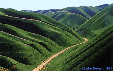
Its landscape features high mountains which bisect the area and arid plains in the north and south as well as fertile valleys
between the mountain ranges. The difficulty of transportation, and the divisions of the country by mountains and deserts,
have contributed to enduring tribal loyalties and the difficulty of unifying the land and preserving that unity.
The Hindu Kush Mountains dominate the landscape with the highest peak, Nowshak, towering almost 24,000 feet above sea level. The Hindu Kush is the westernmost part of the Himalayan range and runs across the country from east to west. The name, Hindu Kush, means, "Killer of the Hindus" and its origin is in dispute. The Pamir Mountain, extend from the West of Afghanistan into Tajikistan, China, and Kashmir. High passes are found in both of these mountain ranges and they form a strategically important network for traders, invaders and fighters. The most famous historical passes were the Khyber Pass and the Kotal-e Lataband pass, both leading from Kabul to Pakistan, and the Kotel-e Salang pass, linking Kabul to northern Afghanistan. In 1960, a road was constructed within the Kabul River's most spectacular gorge, which reduced travel time from Kabul to the Pakistani border from two days to a few hours. Likewise, a tunnel through the Kotel-e Shibar mountain in 1964 reduced travel time between Kabul and the North from 3 days to a few hours. These major routes are currently in great disrepair due to bombing during the fighting over the past 20 years and commercial trade, relief supplies, and other assistance faces great difficulty in traveling these roads. There are four major river systems in Afghanistan, including the Amu Darya (the Oxus of ancient history) which is the current boundary with the Central Asian Republics of Tajikistan, Turkmenistan, and Uzbekistan. Only one of these rivers, the Kabul River, leads to the sea, and even then it flows into the Indus which flows to the sea; many of the rivers and streams empty into the desert. Three large dams have been built in these rivers to provide electricity; while they were not bombed during the wars, they are not functioning well due to looting, lack of maintenance and silting in the reservoirs. The climate is extreme with bitterly cold winters and blazing hot summers. The northern mountains are sub arctic in temperature due to their height, with dry cold winters. Those bordering Pakistan often filter monsoon air masses into central and southern Afghanistan, bringing humidity and rain. Flooding is common as sudden rains may turn streams into torrents; invading armies have been trapped by such flooding more than once as have nomadic tribes. The region lies on a major tectonic fault line and thus is prone to many earthquakes, about 50 each year. The largest recent one was in 1985 when a quake in the Hindu Kush Mountains measured 7.3 on the Richter scale. The country's environment, fragile during the best of
times, faces a great threat today on account of widespread deforestation as trees are felled for fuel and building material.
Many of the mountains are denuded, contributing to erosion and flash floods. Natural disasters such as floods and avalanches,
and the on-going war have also ravaged the nation for the last 20 years The northern plains are relatively fertile and most of the farming is done here. The people produce crops such as wheat, barley, rice and cotton and export fruits and nuts, hand-woven carpets, opium, and textiles to major business partners such as Pakistan, India, and other Central Asian countries. Herding livestock, especially sheep and goats, was a major industry, especially among the nomadic or semi-nomadic tribes. However, much of this livestock that once accounted for almost half of Afghani exports has been lost during the war and rebuilding the flocks is proceeding slowly. The country has the dubious reputation of being the largest producer of poppy seeds in the world; it is from these seeds that opium is extracted and converted to heroin. The poppy grown in Afghanistan is believed to drive a significant portion of the economy and is the main financial support of many of the tribal leaders, often called warlords. Production of opium had declined briefly after September 2001, but it has increased since then and is now a chief item of trade across the Tajikistan border. Afghanistan shares its borders with Pakistan in the Southeast and with Iran in the Southwest. Turkmenistan, Uzbekistan and Tajikistan are its neighbors in the north and China in the east. With all of these countries, including Xinjiang province of China, Afghanistan shares the Islamic religion, as well as a history of nomadism, tribal divisions and conflicts, and trading networks. Around 99 percent of the population follows Islam of which 84 percent are Sunnis while about 15 percent are Shiites. The Sunni tribes share their religion with the other nations of Central Asia while the Shia sect has ties with Iran, which is a Shiite nation. The remaining one percent of the country's population is made up of Hindus, Sikhs, Parsis, and Jews. Pashto (Pushtu) and Dari, a dialect of Persian (Farsi), both Indo-European languages are official languages. More than one-third of the population speaks Pashto, the language of the Pashtuns. About half of the population speaks Dari, the language of the Tajik, Hazara, Chahar Aimak, and Kizilbash peoples. Other languages are spoken by smaller tribal minorities. The Pashtuns are the largest ethnic group in the country. The Tajik are the descendants of the original pre-Turkic people of Afghanistan and form the next largest group after the Pashtuns. The Hazara are believed to be descendants of the Mongol invaders from the time of Genghis Khan.. Chahar Aimak inhabit from the northwestern region of the country while the Kizilbash inhabit Central Afghanistan. Kabul is the nation's capital and is also the largest city. Other major cities are Ghazni, Jalalabad, Herat, Kandahar, and Mazar-e Sharif. As the desert area of the southwest is virtually uninhabited and over two-thirds of the country's population of 20.6 million can be found within 50km of the Ring Road, current rebuilding efforts are focused on the Ring Road that connects Kabul and Kandahar. The road network is expected to drive the country toward economic progress after decades of unrest and economic hardship. |
||||||||||||||||||||||||||||||||||||||
|
[ Go to Top ]
.

|
|||||||||||||||||||||||||||||||||||||||